Vanishing Gods [continued]
And according to Babylonian mythology, the deity Ea, the god of fertilising and creative waters produced a son, Marduk, who created the [southern] Paradise by laying a reed upon the face of the waters, then formed dust and poured it out beside the reed to create the first humans. The water-worshippers of Eridu believed that the Sun and Moon, which rose from the primordial deep, had their origins in the everlasting fire in Ea’s domain at the bottom of the sea; ie the ‘Underworld’ Paradise of Uru.
Berosus of Caldea [270-230 BC] described a race of monster beings, half-men and half-fish which, led by a great culture-bearer Oannes, arrived on the shores of the Persian Gulf, to introduce the arts of agriculture, writing and metalworking to Mesopotamia. In other words, they were skilled mariners; gods who introduced civilisation to Mesopotamia and the rest of mankind.
The spread of Uruan culture by watercraft to Mesopotamia and India could be called the first great maritime expansion. If so, then the rise of Sumer around 3800 BC saw another which spread Sumerian/Uruan influence to the Indus Valley and Persia; to Egypt and Greece; their vessels eventually penetrating beyond Southeast Asia into the West Pacific to ‘re-discover’ their “land of origin”, the mysterious land of Uru. Learning of its vast natural wealth, the god-kings of Sumer dispatched large fleets of ships, loaded with settlers and supplies, to establish mining colonies here of long duration.
Historians credit the Sumerians with the invention of bronze and metallurgy, yet this may have been developed in south-east Asia at an earlier period by megalithic people who claimed a southern origin for their culture. To date, no evidence has been found in Australia to show the Uru had created this art here, although at a few megalithic sites in New England and central western NSW, regions rich in gold, copper, silver, tin and other precious metals, fragments of flattened copper have been found, possibly the remains of crude cutting tools, made by having been beaten cold prior to sharpening around the edges; suggesting the Uru were on the threshold of metallurgy, as the age of smelting was dawning in the Old World.
It would be left to the arrival of Old World mineral-seeking colonists to instruct them in these techniques as the age of Uru faded.
Metal became important to ancient industry during the early stages of the third millennium BC. Prior to this copper tools had been in general use for several thousand years throughout the Old World. Yet copper was too soft. Sumerian metallurgists eventually discovered through experiment that, alloyed with varying amounts of tin [about ten per cent] tools of this mixture were more rigid and sharper, and weapons and armour were stronger.
However, as no minerals were to be found in the flood plains of the Tigris and Euphrates rivers, from the 4th millennium BC, to their destruction by the Amorites in 1930 BC, the rulers of Sumer, followed by those of India, dispatched large fleets into the world’s oceans in search of them, especially into Australasian waters.
Traces of ancient mining activity shows they found good quantities of tin in island Southeast Asia. There is also evidence that they mined tin, copper and gold in West Irian and also the North-West Kimberley region of Western Australia, which would come to be known as ‘Arali’, meaning “basement” of the earth, the ‘Underworld’, and “place of the shining lodes” in reference to the great amount of silver mined there. It also became known as “the land from which the metal ores come”.
Ancient Sumerian traditions speak of their colonists having overpowered the local [Uru and Aboriginal] inhabitants, and enslaving them to work in the mining operations. My book, “Pyramids in the Pacific” gives a full account of Bronze-Age Sumerian presence in Australia, and its eventual demise due to the collapse of their civilisation at home. However, other sails were appearing on the horizon as the Bronze Age [2000-1400 BC] began, and soon Phoenicians, Celts, Libyans and Egyptians would have an even greater impact upon the Uruan civilisation.
A number of important
archaeological sites in Australia and
New Zealand demonstrate the longterm
nature of these colonies and the
influence they had upon the
indigenous Uruan culture, and they
certainly left their influence upon the
culture of our Aboriginal people over a
wide area of the continent.
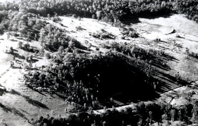
The Gympie
Pyramid
Note the
causeway that
extends from left
of picture.
A
stone wharf once
stood at the
southern base
[in from the road],
the pyramid being
on the edge of the
former harbour.
Photo copyright © Rex Gilroy 2004.
At Gympie, north of Brisbane,
in October 1975 I identified a
crumbling, tree-covered, terraced 60 m
tall by 125 m square, four-sided stone
structure as a step pyramid,
reminiscent of those built in Egypt
during the 3rd dynasty period, from
about 2650 BC to the 4th dynasty
about 2720 BC, when the step
formation was superceded by the true
pyramid design. The late Mrs Ethel
Loughman, then 73 years old,
informed us that 19th century settlers
had found a shaft that dropped down
deep into the ground, and from which
a stone-lined tunnel continued on deep
into the structure from the western
side.
Some locals tried to penetrate it
without success. The shaft was
eventually filled in to prevent children
or livestock falling into it. The “Gympie Pyramid” as I
named it, faced the four points of the
compass. In March 1976, near the
structure’s western base, I unearthed a
34cm long by 15.5cm wide crude
ironstone idol. It resembled others
from Egypt of the god Thoth in ape
form clutching the Tau, of “Cross of
Life”.
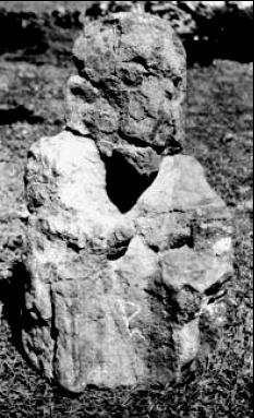
It was not the first Thoth ‘ape’
idol to be found hereabouts. Ten years
earlier, in 1966, farmer Dal K Berry
[since deceased], while ploughing his
field, one day unearthed a 72cm tall by
120cm circumference ironstone idol within sight of the pyramid.
The “Gympie Ape” idol
[Egyptian God Thoth in ape
form], unearthed
by the late Dal
K. Berry in 1966.
Photo copyright © Rex Gilroy
The idol
was later identified by me as the god
Thoth [inventor of writing] in ape
form. Carved between the legs was the
papyrus flower symbol, denoting
Thoth as the god of writing and
knowledge. Thoth was depicted as an
ape prior to around 1000 BC, when he
became an Ibis-headed, human-bodied
deity, who recorded the judgement of
the dead in Amenti, the afterworld.
As long ago as the mid-19th
century European settlers and miners,
who had entered the district after
1867, when James Nash discovered
gold here, began turning up mystery
rock inscriptions and remains of
ancient pottery of middle-east design,
and many other relics of apparent
Phoenician and Egyptian origin. The
early settlers and miners discovered
ancient open-cut gold and copper
mining operations and crumbling large
stone structures in the nearby
mountains, which showed the district
had been settled and mined in the dim
past.
Geological evidence shows
that, at the time the pyramid was
constructed, a great harbour extended
from Tin Can Bay, 36 miles [approx
24km] to the east, through Gympie
and far out into now open farmland.
The pyramid stood on the northern
shoreline of this wide, deep harbour.
Aboriginal traditions of the
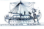
area state that, in the long-ago“Dreamtime”, a race of fair-skinned“culture-heroes” sailed into Gympie in
big ships shaped like birds - suggestive
of the old Phoenician triremes, which
often possessed bird-headed prows
among other figureheads.
These culture-heroes spent a
considerable period of time in the area,
during which they built the “sacred
mountain” in which a great chieftain
lived, and from which they worshipped
the Sun and Stars. They also dug holes
in the hills and removed the rocks
which they transported out to sea. Eventually they sailed away, promising
to return.
How else could primitive
Aborigines have described ancient
mining operations? The evidence
suggests Gympie was once the scene
of a joint Egyptian-Phoenician mining
colony.The local tribespeople regarded
the pyramid with awe, believing it to
be a very sacred place, for their
Supreme Being, the Sun-God Biame,
lived on the summit.
The sad fate of the Gympie
Pyramid at the hands of ‘treasurehunters’,
religious fanatics and other
vandals is related in my book“Pyramids in the Pacific”.
There had once stood a crude
stone altar and libation bowl upon the
flat summit, [smashed, I was told years
later, by a sledge-hammer wielding‘Christian’].
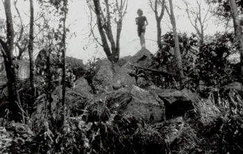
I had not seen the pyramid for
many years following the vandalism,
when in August 1993, while passing
through the city, I paid a visit to the
pyramid, now a virtual hill of rubble
The Gympie Pyramid
Large Boulders On The Summit
Photo copyright © Rex Gilroy 2004.
However, atop the structure, beside
where the altar and libation bowl had
formerly rested, partly exposed on the
surface, I noticed a stone bearing a
carved symbol. Digging what turned
out to be a large, heavy oblong
ironstone slab from the ground, I
found it bore a message in Egyptian
hieratic script, later translated to read:“Leave offerings of fruit at this stone
for the god.”
The vandals had also missed
another relic. Returning here in May
1995, about half way up the southern
face of the pyramid I found a large,
ironstone phallic image, inscribed
upon all sides, with a mixture of
Egyptian, Libyan and
Phoenician
symbols, later translated
to read:“Na-ta-wah, Pharaoh of this land,
commands you to assemble here to worship Ra.”
Who was Pharaoh Na-ta-wah?
Was it for him that the Gympie
Pyramid was built? And what of the
tunnel? Did it lead to a burial
chamber? We may never learn all the
answers to this mystery, for not only
was a railway line allowed to be
constructed along the western base of
the pyramid, but a housing
development now covers its northern,
eastern and southern sides!
The evidence is that, the
Gympie colony and its population
became so large that it warranted the
establishment of a local ruling class.
This was the case with other
large colonies established at Sarina,
North Queensland, in the New
England district and also at Brisbane
Waters on the Central Coast of NSW,
north of Sydney near the Hawkesbury
River.
Our researches around Sarina
harbour, near Mackay, North
Queensland, have identified extensive
megalithic ruins, including a stone
wharf and nearby pre-European age
open-cut gold, copper, tin, silver, iron
and other mining operations, as the
work of Phoenician colonists, who
settled the district in biblical times.
The fact that iron was mined
hereabouts places the colony’s age as
late as the Iron Age, around 1400 BC.
There are also the wel lpreserved
remains of a small temple,
an ancient cemetery, and the apparent
remains of an ancient 4 -5 square acres
barley field, with grid patterns still
visible amid its dense rainforest
covering.
Heather and I commenced a
preliminary inspection of the district in
September 2000, beginning with a
massive wharf composed of rocks and
minerals of considerable variety, many
of which had been transported to the
site from beyond the Sarina district,
including offshore Great Barrier Reef Islands, which had been mined for
their deposits of copper, gold and
other precious metals.
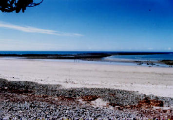
The wharf, which is 6 m in
height by 800 m in length by 30 m
width, parallels surviving Phoenician
examples in Lebanon, the stones
having been set in slag cement.
Here triremes would have
brought ores from the offshore islands
and other mainland mining sites to the
north and south of Sarina, which after
sorting were processed in at least two
large stone smelters, whose remains
now lie partially submerged on the
harbour foreshores. The precious
metals would then have been loaded
into triremes for the voyage back to
the Red Sea, from where, we assume,
overland caravans carried them to
Egypt and other fabled Mediterranean
lands.
View of the far end of the Sarina “Phoenician Wharf”.
Photo copyright © Rex Gilroy 2004.
The wharf is covered in ore
chips and minerals, identified as
Copper, Tin, Silver, Gold, Quartz,
Calcite, Cinnabar, Lapis Lazuli and
others. Hereabouts I found fragments
of thin bronze sheeting turned green
with age, and which had been
produced from tin and copper smelted
locally. Heather and I inspected three
open-cut mines excavated through
solid basalt by unknown means, from
which mercury and gold were
extracted. Fine gold dust coating the
cliffsides sparkled in the morning
sunlight.
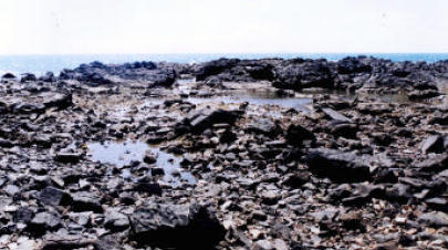
Upon a huge basalt slab facing
the harbour at another location where
gold had been mined, I found a
number of large, weathered
Phoenician
glyphs, stating:“Guard the land on which this mine stands,
for it contains
an ever-increasing
amount of gold.
The gold of Baal the Sun who is above all.”
Stretching out beyond the
shore was a man-made headland
leading to a rocky outcrop showing
signs of ancient mining. Hereabouts lay ore fragments and samples of Lapis
Lazuli.
At the temple, mentioned
previously I found two small
Phoenician glyphs stating, “Guard this
enclosure”. Possibly it was built for the
worship of either the Celtic Bel or
Phoenician Baal Sun-Gods, but a
further identifying inscription is
needed for a positive identification.
The ancient cemetery contains
at least 60 graves, but like the barley
field, there must have been many
more, due to the enormous population
that had to have occupied this colony.
So just how many people were
involved in these operations and how
long ago?
It can be safely estimated that
at least 3,000 people lived hereabouts
at the height of the colony’s existence
[the Gympie colony population was
about the same figure]. As tin and
copper was mined here to produce
bronze, the colony must date back to
Bronze-Age times [2000-1400 BC],
and as iron was also mined this implies
the colony continued on into the Iron-
Age, which began around 1400 BC
when this precious metal was
discovered by the Hittites. Thus the
colony surely existed for a considerable
period of time. We suggest up to 2,000
years.
Just prior to our Sarina
investigation, Heather and I visited
Bowen, further north up the coast, in
search of similar evidence. At one
particular beach, half buried in sandy
soil high up on the shoreline, I
uncovered a curiously shaped slab of
yellowish sandstone, which turned out
to be the carved profile of a human
head, with left ear, eye, nose and
mouth. Above the eye and nose ridge
were five unmistakable Phoenician
glyphs. Nearby on the waterfront I
also found a rock shoal bearing further
large, deeply cut Phoenician glyphs.
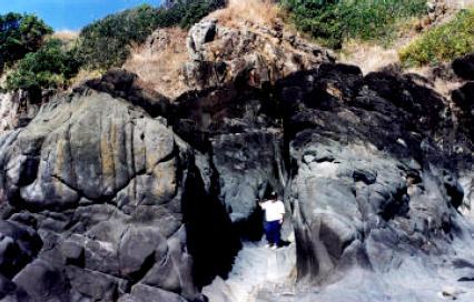
Heather Gilroy
examining one
of the Sarina
Bronze Age
waterfront gold
mines.
The
open-cut
operation was
made through
solid basalt.
How did the
ancient miners
do it?
Photo copyright © Rex Gilroy
2004.
 20 Metre Long Galley
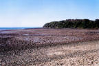
 Stone Ship’s Anchor
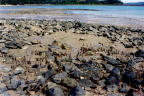 Ancient Smelter
 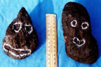 Carved Heads